June 30, 2008

The Mountain

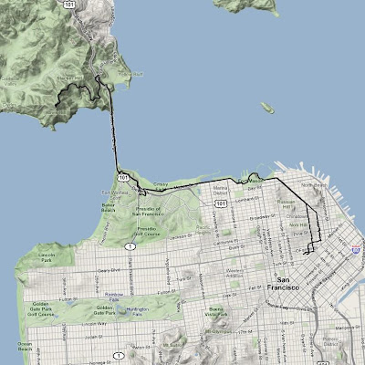
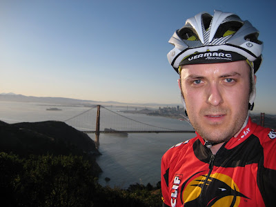
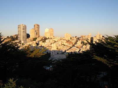
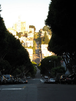
While in San Francisco a couple weeks ago I spent one afternoon riding Mt. Tamalpais. Mt. Tam is probably the closest mountain to San Francisco, located about 20 miles north of the city in Marin County. This was the fourth time I've ridden it and it holds a special place in my heart as the first mountain I ever rode on a bicycle.

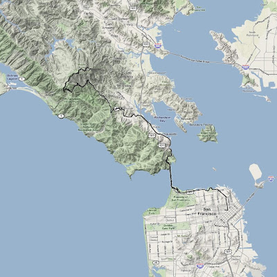
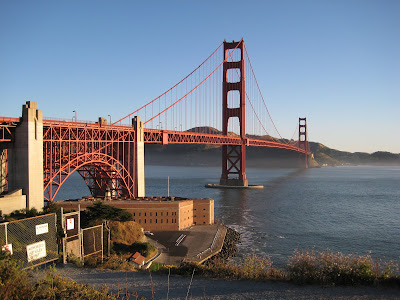
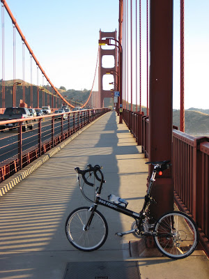
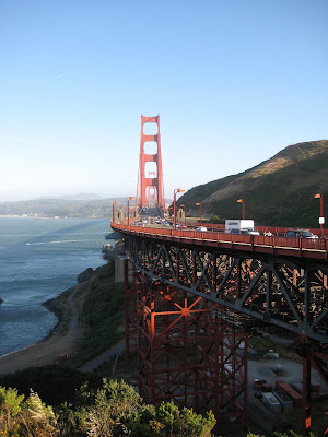
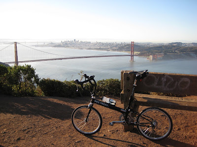
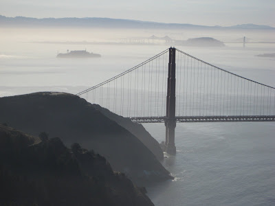
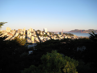
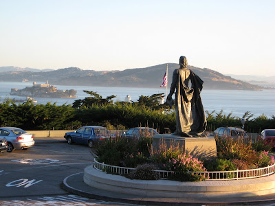
I started in downtown San Francisco and made my way out of the city, over the Golden Gate Bridge (which I rode 5 times during the trip). It was so foggy that day I literally couldn't even see the bridge until I was on it. As I was approaching the bridge I passed two tourists on rental bikes intently studying a map, looking around, and pointing different directions. As I passed I called out to them, "Are you looking for the bridge?" They replied, "Yes." I responded, "It's this way." I have been there several times before, but no matter where I travel I always seem to be the one who gives directions to other tourists, despite the fact that I don't actually live in these places.

Once over the bridge there is a nice little descent into Sausalito. There are a lot of bikes in this area as well. One of the popular routes for tourists on rental bikes is to cross the bridge to Sausalito, then take a ferry back to San Francisco rather than ride back (it's a little hillier than the average tourist can handle). The route to Mt. Tam follows the bay for a few miles before shooting inland.

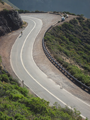
Mt. Tam is a little over 2500 ft high. The main climb is 10 miles long and averages around 5% gradient (though this includes a few downhill sections, it's mostly steeper than that). It starts on a very curvy section California Highway 1 at Tamalpais Valley Junction, just slightly above sea level. These first two miles can have a fair amount of traffic, depending on the time of day. Fortunately, this road is also heavily travelled by bicycles, so nearly all the cars behave sensibly when they encounter a bike. There wasn't a whole lot of traffic on the afternoon I chose.

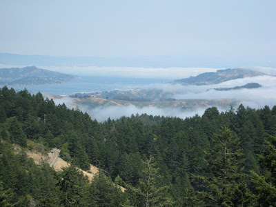
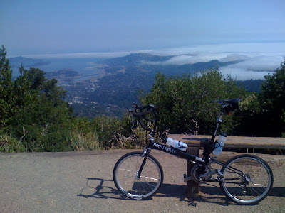
After turning off California Highway 1, there really wasn't much traffic for the remaining 8 miles. Once I reached about 1200 ft of elevation I broke through the fog & clouds and it was perfectly clear and sunny. In fact, once I got to about 1600 ft the sun was absolutely blistering. I was sweating profusely and going through water like it was... er, water. I even got sunburned. This was not what I was expecting when I left town, given I could only see a couple blocks ahead of me.

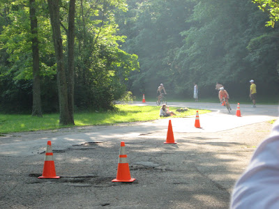
I had been looking forward to this ride literally for months, so you can imagine how I was feeling when halfway up I entered Mt. Tam State Park and saw this:

Audrey, when they close the road they put up big signs, like this one

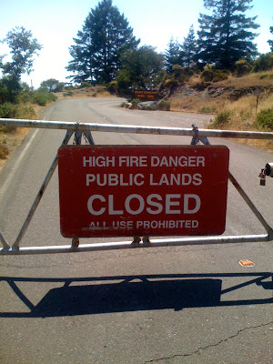
I was pretty devastated. I stopped riding and walked across the road to the ranger station. I found a map and started to plan the remainder of my ride (I still had a few hours to kill). Maybe I wouldn't get to ride all the way to the top, but I would still try to find somewhere interesting to go. As I was standing there I overheard a couple of hikers chatting with the ranger. The ranger was telling them it was okay for them to go hiking up on the mountain. Hmmm. After they left I walked over to the ranger and asked about biking. I was delighted to hear that the road was only closed to automobiles, and bikes were quite welcome to continue up the road. So I can just walk around the gate and keep riding? Apparently.

This turned out to be a blessing in disguise because there was no auto traffic on the road for the last half of the ride. I was basically all by myself (well, there were some horseflies).

From 1800 ft I could look down at the clouds rolling in from the Pacific

From 2500 ft (west peak) I could see the downtown skyscrapers over the clouds

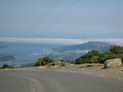
Mt. Tam has three peaks (west, middle, east). The east peak is the highest, though the road doesn't go all the way to the top. The west peak is slightly lower, but the elevation of the road is the highest there (a little over 2500 ft). The two steepest and hardest sections of the entire ride are right as you reach the east peak and right as you reach the west peak. Go figure.

The Pocket Rocket at the east peak

At the top I filled my water bottles and ate a couple Clif Bars. There was a soda machine which appeared to have cold lemonade for $1, which sounded perfect. I reached for my wallet only to discover a lone $20 bill. Damn. I made due with water.

Now the hard work was over, it was time to coast for 40 minutes (okay, there were a few small uphill sections on the descent). The first 8 miles of descent were traffic free. About a quarter mile after turning onto Highway 1 I caught up with a car (yes, I was going significantly faster than the cars downhill) and had to follow it the remainder of the way down (there was no room to pass). I broke my $20 bill for a bottle of Gatorade at a gas station at the bottom of the descent. Then I made my way back to the city.

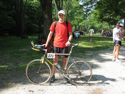
What a great ride. The best part was seeing how well my little Pocket Rocket held up. Not only was it great at climbing, it handled amazingly well at around 40 mph on the descent. It truly is a no compromises travel bike.

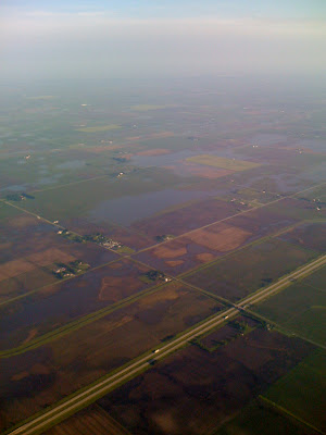
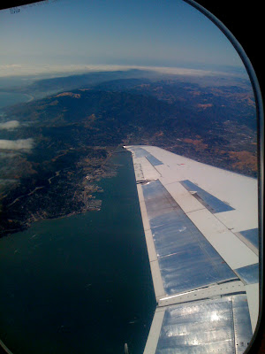
I got one last view of Mt. Tam as I was flying out of the San Francisco airport. If you follow the wing all the way to the end, then look up you can see Mt. Tam.

Ride Information
Date:2008-06-13 1:24 PM PDT
Mountain:Mt. Tamalpais
Road Elevation:2492 feet
Climb Distance:10.0 miles
Climb Ascent:2492 feet
Climb Average Grade:4.7%
Climb Maximum Grade:20%
Ride Distance:49.5 miles
Ride Total Ascent:5685 feet
Ride Maximum Speed:37.4 miles/hour
Ride Start:San Francisco, CA (0 feet)
Ride End:San Francisco, CA (0 feet)

June 29, 2008

The Proctor Classic

Today was the Proctor Classic criterium bicycle race in downtown Peoria. I, along with six other Wild Card Cycling riders, did the Cat 5 (i.e. beginner) race. The good news was that we had a pretty sizable group of very good riders who can work well together. The bad news was that it was a criterium, by far my least favorite type of bike race. The course was a one mile loop on closed (unlike West Lafayette) city streets. There were eight turns each loop, most of which were only separated by one block each. This is a lot of turning, and the speed was high, and that always makes me a little bit nervous.

Rob before race

Mark & Rob on lap two

Karl & Thomas

The race started well enough. I was near the front. I dropped a few positions each turn and I moved up a few positions on the longer straight sections. On the third lap I was near the middle of the pack when the guy right in front of me (it's always* the guy right in front of me) slid out in one of the turns. I had to brake hard and turn sharply to avoid running into him. This crash split the field in half. I accelerated as soon as possible, but at the point it was too late. The front half of the field had a gap and they were going too fast for me (or anyone else behind the crash) to catch them.

I rode the rest of the race by myself. It kind of sucked to watch the leaders pull farther ahead of me each lap, but at the same time it was a bit of relief to not have to worry about other riders in the turns. Nobody passed me the rest of the race, while each lap I would pass one, or two, or three riders who dropped from the lead group.

Mark, Stew, Tom, & Dan in the lead group

Mark, Dan, Tom, & Stew in the lead group

Tom & Stew

Rob chased alone almost the entire race, but never caught the leaders

Tom finished 2nd, Stew finished 3rd

I don't know all the details how the race unfolded at the front, but Tom finished in 2nd place, and Stew finished in 3rd. Dan and Mark also finished in the top dozen or so. I'm 95% sure I was the first person to finish behind the lead group, but the results showed me near the bottom of the field. I questioned the race official about this and she agreed this was incorrect. She went to go re-figure the results while we waited around and watched the next couple races. I never did hear back. I wonder what my official place will be...

After our race was a junior race. Next was the Masters Cat-1,2,3 race, which was won by Dave Stone, a guy who sometimes trains with us. There were many other races throughout the day, but Melissa and I had to take off at this point to visit her parents before heading back to Urbana to walk Ravage (we were dog-sitting).

Dave Stone (who sometimes trains with us) won the Masters Cat-1,2,3 race

So the race went well for the team, as well as other local riders. It was only so-so for me, but at least I learned a few things. Next time I will be a little wiser and hopefully a little luckier.

* As a side note, a rider directly in front of me has crashed at some point in five of the seven mass start bike races I've done (all four criteriums and one of the three road races). Fortunately, only one of them took me out as well. The lesson is don't ride directly in front of me.

Update: The results have been posted and they correctly list me behind Mark, which as it turns out was 17th.

June 25, 2008

The Confirmation

After ten years of running (1993-2003) and two full seasons of triathlons (2002 & 2003), I tore cartilage in my left knee while running in the spring of 2004. This put both my running and triathlon enjoyment on hold. After months of trying to get back to running and arthroscopic surgery a year later it became clear that running was no longer an option for me. While giving up running was very hard for me, my consolation was that I was still able to bike. Bicycling (which I really only started as a means to an end, triathlon) became my only fitness outlet. Since that time I have biked most days, traveling tens of thousands of miles by my own power.

Last August, after nearly four years off running, I decided on a whim to run a bit. It went well. A few days later I ran again and it went well again. I started running once a week, then twice a week. I mainly ran on grass and dirt, rather than concrete and asphalt, since it is easier on my knee. I slowly started to get my speed back.

By the end of October I felt ready to do a race, the Deuces Wild Duathlon. It had a 2 mile run, a 20 mile bike, then another 2 mile run. I made a good effort and ended up 7th overall and 1st in my age group. At this point I was pretty sure I could make a full return to triathlon.

I did several short races (and one loooong one) over the winter and spring (with some success), but I was really just biding my time until summer. I needed to compete in a triathlon to confirm to myself that the old Rob was back.

Last saturday was the day. Melissa & I travelled to Indianapolis, where I did the Indianapolis Sprint Triathlon at Eagle Creek Park. It was a short race, with a 500 yard swim, a 10 mile bike, and a 3 mile run. I did this race in 2002. In that edition I got a flat tire, which took about 9 minutes to fix, and still finished respectably. I was pretty sure I could do better this time around.

The race was packed. There were over 600 people registered and there was huge, slow moving, line to pick up packets before the race. This caused me to completely miss my warm up before the race.

The swim was harder than it should have been. It was only 500 yards, but I had only swam 4 times this year prior to the race. Yes, this was dumb. I was underprepared and it showed. I swam kind of slowly. In the past I would typically finish roughly 60th for the swim in a race this size, where on Saturday I finished 86th. Not terrible, just a little rusty.

My first transition (swim to bike) took an eternity. Not only did I not practice swimming enough, I didn't practice using my wetsuit at all. After nearly 5 years I had a really difficult time taking the damn thing off. The transition took about a minute longer than it should have.

The bike went amazingly well. The 5 years of practice I've had really showed. I passed way way way more people than I've ever passed in a triathlon bike leg, and I was passed by far fewer people than any other tri I've done. In the past the bike leg was always by far my weakest, but that is no longer the case. I finished the bike with the 30th fastest split, averaging 22.2 mph for a not particularly fast course. The beginning of the out and back course had lots of turns. The middle section had big bumps every 50 meters.

The second transition went much more smoothly. Nothing notable to mention.

The run was okay. Running after biking is always a little weird. Even though I never practiced this in training, my body handled it pretty well. My legs felt great, but I started to get side stitches while running. This generally doesn't happen to me, and it was unfortunate that when it did happen it was during a race. I would have liked to have run faster, but I'm content with how it went. My run split of 19:33 (6:31 pace) was the 39th fastest. I was hoping to run under 19:00, with a pie in the sky goal of closer to 18:00.

I finished 36th overall (out of 559 finishers), and 8th in my age group (for which I won a race towel). At some point in the past 5 years triathlons changed age grouping from age on race day to age at the end of race year, meaning I was competing as a 30 year old. The 30-34 age group is typically much tougher in triathlons than 25-29.

I did well, but I had room for improvement. The good news is that the old Rob is back. Surely I will have a few more chances this summer to compete in other triathlons and hopefully continue to improve.

June 17, 2008

The Marin Headlands

We were in San Francisco for seven days. I was able to go on a bike ride five of those days. Every single bike ride I did I crossed the Golden Gate Bridge. There are (at least) two reasons for this. First, the path along the northern coast of San Francisco combines with the bridge to form several miles of continuous roads/paths with very few stop lights or stop signs. Riding through the city is fun, but stopping every other block at a stop light is not the best way to get a workout. Second, just on the other side of the bridge lie the Marin Headlands.

The headlands are the hilly area at the southern tip of Marin County, just north of San Francisco. San Francisco is known for it's hills, and while many of these hills are quite steep they are typically only 200-300 ft high. Hawk Hill, in the headlands, is 920 ft high. This is the closest big hill to San Francisco. Additionally, it provides an absolutely spectacular view of the city, bridge, and bay.

One of the routes I took to Hawk Hill

Approaching the Golden Gate Bridge from San Francisco, with the Marin Headlands in the background.

The bridge has wide paths on both sides. One is for pedestrians & bikes, the other is for bikes only.

The hills rise up immediately from the bay on the north side of the bridge.

The climb up Hawk Hill is 1.8 miles long and ranges from 3% to 12% gradient with an average of 7%.

I rode Hawk hill three times last week. The first time I had a meeting immediately following the ride, so I was really moving, around 9-10 mph. The second time I wasn't quite as pressed for time, but I still needed to make it back in a timely fashion and averaged 8-9 mph. The third time was a much longer ride (3 hours) with no tight schedule so I rode a more leisurely 7-8 mph. At the rate I was getting slower each day it's a good thing I didn't stay another week or I may not have been able to maintain forward motion...

The view from the top did not disappoint. It was crystal clear on the first trip.

The second trip was a little foggy.

"Classic Rob" according to Meli

With any luck, this will be an interactive 360˚ panoramic view from the top of Hawk Hill. Click on the image and drag the mouse left and right to change the view.

June 14, 2008

The Telegraph Hill

On Wednesday morning I headed out towards the Golden Gate bridge for a bike ride. I headed north on Kearny intending to turn left onto Columbus when I saw a monster hill. Kearny St. headed up Telegraph Hill is steep. It is closed to auto traffic. I tried to ride up this street on the Dahon a few years ago, but after slowing to a complete stop I had to get off and walk the bike the rest of the way. This time I was on the Pocket Rocket, so I figured I'd give it another go. It was still steep, but I made it without too much difficulty (though I'm kind of glad it was only one block long). From there I was close to half way up Telegraph Hill and I had never been to the top, so I figured why not go the rest of the way.

Coit Tower is at the top. This was built as a memorial to the firefighters who died in the 1906 earthquake fire. It is an impressive building, and Telegraph hill provides beautiful views of the city.

Coit Tower

San Francisco from Telegraph Hill

San Francisco from Telegraph Hill

A statue of Columbus is in front of Coit Tower. Alcatraz can be seen in the background.

Lombard St. from Telegraph Hill towards the crooked section at the top of Russian Hill

The Flooding

Rains of biblical proportions hit Champaign County last week. Champaign county is very flat and the water doesn't really go anywhere, so there was a lot of flooding. I spend a lot of time bicycling through the country side and I have seen standing water in just about every field. Several roads were under a foot of water. The flooding was even more apparent when viewed from above, as I was flying out of Champaign last Sunday morning on my way to San Francisco.

A lot of fields in Champaign county were flooded last week

June 10, 2008

The 2008 WWDC Keynote

Yesterday was the keynote presentation for the 2008 Apple Worldwide Developer Conference (WWDC) in San Francisco. The big news Steve Jobs announced during the keynote was a new iPhone revision with faster cellular networking (nice in theory but only available in major cities, i.e. nowhere near where I live), GPS (yay), a lower price tag (yay), better battery life (yay), a non-cracked screen (I suppose the original model has this feature as well, until you drop it on concrete), and a higher monthly service fee to AT&T (boo).

2008-06-10-Cracked-Screen
Stupid cracked screen

Even more interesting to me is the iPhone 2.0 software (which will also be available for first generation iPhones) which allows 3rd party applications to be installed and run. This was originally announced a couple months ago but a few more details were provided during the keynote. There were also lots of demonstrations from 3rd party developers who have been working on games, productivity, and educational applications for the iPhone. Who knows, maybe the DataBook software will be available on an iPhone in the future...

June 4, 2008

The Landprint

Z Corp, a company who partners with my employer, recently launched a new online printing service called Landprint to create 3D maps of user selected regions of planet Earth. The full topography is printed in 3D and colored to match satellite photos.

I love maps, so I couldn't pass up the opportunity to try this out. The choice of locations was clear--my former home, Ometepe island in Nicaragua.

Landprint of Ometepe island in Nicaragua

Profile view of the Landprint

Here's my hand for scale. It's kind of small.

It's made of a hard sturdy resin. I knew it was going to be small, but I underestimated just how small 4" was. That's okay, because the thing is really neat. They make objects slightly larger but they get prohibitively expensive pretty quick. The 4" model was priced closer to the impulse buy range.

June 1, 2008

The End of May

Just a week or two ago we had low temperatures in the 30s and now we have highs in the 80s. It's like we skipped Spring this year and went directly from Winter to Summer. My May bike mileage was slightly up from March & April, but still not quite as high as that of 2006.

May 2008

BikeDistance# RidesAvg per Ride
Bianchi36.14 Mile66.02333 Mile
Big Red8.95 Mile18.95 Mile
Bike Friday23.03 Mile123.03 Mile
Dahon46.43 Mile67.73833 Mile
Litespeed20.23 Mile36.74333 Mile
Thundercougarfalconbird530.28 Mile1927.9095 Mile
Total665.06 Mile3618.4739 Mile

Jan - May 2008

BikeDistance# RidesAvg per Ride
Bianchi328.77 Mile536.20321 Mile
Big Red31.09 Mile47.7725 Mile
Bike Friday23.03 Mile123.03 Mile
Dahon158.13 Mile285.6475 Mile
Litespeed73.33 Mile514.666 Mile
Thundercougarfalconbird1715.81 Mile5332.3738 Mile
Total2330.16 Mile14416.1817 Mile